Virtual Pacifica To Half Moon Bay, Simulated Flight Tour and Geographical Overview
Virtual Pacifica To Half Moon Bay is a geographical overview, using simulated flight and Google Map tools,
of the west coast of California near San Francisco. Includes views of the San Francisco Bay and peninsula as
we follow the Pacific Coast Highway before landing at Half Moon Bay. Information about San Francisco tours as
well as live controllable San Francisco Webcams are also presented.
Views in Virtual Pacifica To Half Moon Bay also include: Daly City, San Francisco International Airport,
SanBruno Mountain State Park, Pacifica, Rockaway Beach, Pedro Point, San Pedro Valley Park, McNee
RanchState Park, Gray Whale Cove State Beach, Montera, Moss Beach, Miramar You can refer to the Google
Earth Map for more.

Contents:
San Francisco Tour Descriptions
More Virtual San Francisco Tours
Pacific Coast San Francisco Part 2 - Pacifica To Half Moon Bay
View Pacifia To Half Moon Bay in a larger map Back To Top
San Francisco Tour Descriptions
Virtual Pacifica To Half Moon Bay (Tour seen above)
In this second part of the Virtual Coastal San Francisco tour we find ourselves flying off the coast just north of
Pacifica. We are still following the Pacific Coast Highway headed towards Half Moon Bay. We pass Pacifica and
Rockaway Beach as we curve around Pedro Point and get good views of San Pedro Valley Park and McNee
Ranch State Park east beyond the rocky cliffs. We fly past Gray White State Beach, Montara and Moss Beach
before this part of the tour ends.
This Virtual Pacifica To Half Moon Bay video was created under Microsoft’s “Game Content Usage Rules” using assets from Flight Simulator X, © Microsoft Corporation.
More San Francisco tour information coming soon.
___Webcam Views: Click on the cameras below.
Kite Surfing view from the Exploratorium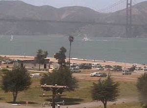 |
Golden Gate Bridg View from the Exploratorium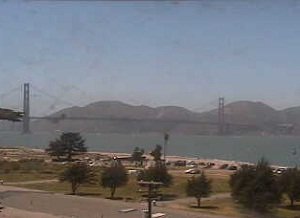 |
When its your turn to control the camera, use the mouse to control view. Back To Top
More Virtual San Francisco Tours
San Francisco Tours Part 2 - Candlestick Park To The Golden Gate Bridge
Part two picks up over Candlestick Park and Bayview Park as we continue north towards Downtown San
Francisco, East on the other side of the Bay we can see Oakland off in the distance . . .
Pacific Coast San Francisco Part 1 - Golden Gate Bridge To Pacifica
In this first part of Virtual Coastal San Francisco Tours we begin with flight over South Bay and Land's End just
off San Francisco Bay. Here we have a great view of the Golden Gate Bridge, The Presidio and . . .
Pacific Coast San Francisco Part 2 - Pacifica To Half Moon Bay
In this final coastal San Francisco tour we are entering a traffic pattern to Half Moon Bay Airport. Before turning
into the bay we get views of moss beach the airport, El Granada and Mirmar Beach. At the far southeast end . . .
Check back for new Virtual Travel Tours, or Subscribe to VTT RSS Feed for updates.
Virtual Pacifica To Half Moon Bay: Back To Tour Video
Please Comment and Share
Back To Top
Site optimized for Firefox
_Download
More Tours

Candlestick Park To The Golden Gate Bridge

Golden Gate Bridge To Pacifica

Comment on this video? click here


New! Comments
This site is still in its development stage. Please let me know what you think about this page.